NAVITEL E700

NAVITEL E700 is a car GPS navigation device with a bright 7-inch touch screen. The navigator runs on a highly reliable OS Windows CE and uses preloaded offline maps which means it does not depend on cellular signals.


One of the main advantages of NAVITEL E700 is an extended map package that includes detailed maps of all European countries, Belarus, Kazakhstan, and Russia. Maps feature over 5 000 000 POI such as restaurants, hotels, banks, pharmacies, stores, filling station, and historical landmarks.


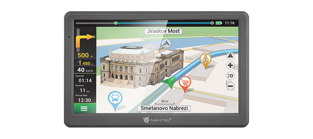
Proprietary software Navitel Navigator can build routes instantly. It features turn-by-turn voice directions, visual prompts, lane assist with 3D junction view and SPEEDCAM alerts.

Contents

NAVITEL E700 Personal Navigation Device
Car holder (windscreen)
Car charger 12V
Mini-USB cable
Stylus
User Manual
Warranty card

NAVITEL E700:

Basic
Software
Navitel Navigator
Jau uzstādītās kartes
47 maps
The ability to download additional maps
yes
Free map updates
yes
Route calculation function
yes
Route time calculation
yes
Speedcam alert
yes
Features
Three alternative routes
yes
Voice prompts
yes
Built-in speaker
yes
Cargo graph
yes
Display
Screen size
7"
Screen type
TFT
Screen resolution
800х480
Touch screen
yes
Screen illumination
yes
Tech specs
Operating system
Linux
CPU
Mstar MSB2531, Cortex-A7
CPU frequency
800 MHz
Antenna
internal
Navigation system
GPS
Waterproof
não
Memory
RAM
128 MB DDR3
ROM
8 GB Flash
Type of memory cards
microSDHC
Maximum card size
32 Gb
Power
Battery type
built-in lithium-ion
Battery capacity
1500 mAh
Connecting an external power supply (12 V)
yes
Power supply
to the navigator
Interfaces
Wi-Fi
não
Connection
mini-USB
Headphone jack
mini-jack
General
Windshield mount
suction cup
Mount to holder
mechanical
Stand holder
yes
Location of the stylus
in holder
EAN
8594181740357
Warranty
Warranty period
24 months

Maps

NAVITEL E700 is delivered with pre-installed maps of 47 countries.


Every map includes residential and industrial infrastructure with address search and detailed road network with traffic direction, interchanges, roundabouts, and other relevant information. There is also a huge POI database (filling stations, ATMs, restaurants, etc.) and an extensive SPEEDCAM database.

Albânia
Albânia
Andorra
Andorra
Áustria
Áustria
Belarus
Belarus
Bélgica
Bélgica
Bulgária
Bulgária
Bósnia e<br>Herzegovina
Bósnia e
Herzegovina
Chipre
Chipre
República Checa
República Checa
Croácia
Croácia
Dinamarca
Dinamarca
Estônia
Estônia
Finlândia
Finlândia
França
França
Alemanha
Alemanha
Gibraltar
Gibraltar
Grécia
Grécia
Hungria
Hungria
Islândia
Islândia
Ilha de Man
Ilha de Man
Itália
Itália
Cazaquistão
Cazaquistão
Látvia
Látvia
Liechtenstein
Liechtenstein
Lituânia
Lituânia
Luxemburgo
Luxemburgo
Macedônia<br>do Norte
Macedônia
do Norte
Malta
Malta
Moldávia
Moldávia
Mônaco
Mônaco
Montenegro
Montenegro
Holanda
Holanda
Noruega
Noruega
Polônia
Polônia
Portugal
Portugal
Romênia
Romênia
Rússia
Rússia
San Marino
San Marino
Sérvia
Sérvia
Eslováquia
Eslováquia
Eslovénia
Eslovénia
Espanha
Espanha
Suécia
Suécia
Suíça
Suíça
Ucrânia
Ucrânia
Reino Unido
Reino Unido
Vaticano
Vaticano

Documentation